Research Catalog
Color image map : [ports of entry, United States-Canadian border]
- Title
- Color image map : [ports of entry, United States-Canadian border] / prepared and published by the U.S. Geological Survey in cooperation with the Department of the Treasury, U.S. Customs Service.
- Author
- Geological Survey (U.S.)
- Publication
- Reston, Va. : The Survey, 1977-1978.
- Supplementary Content
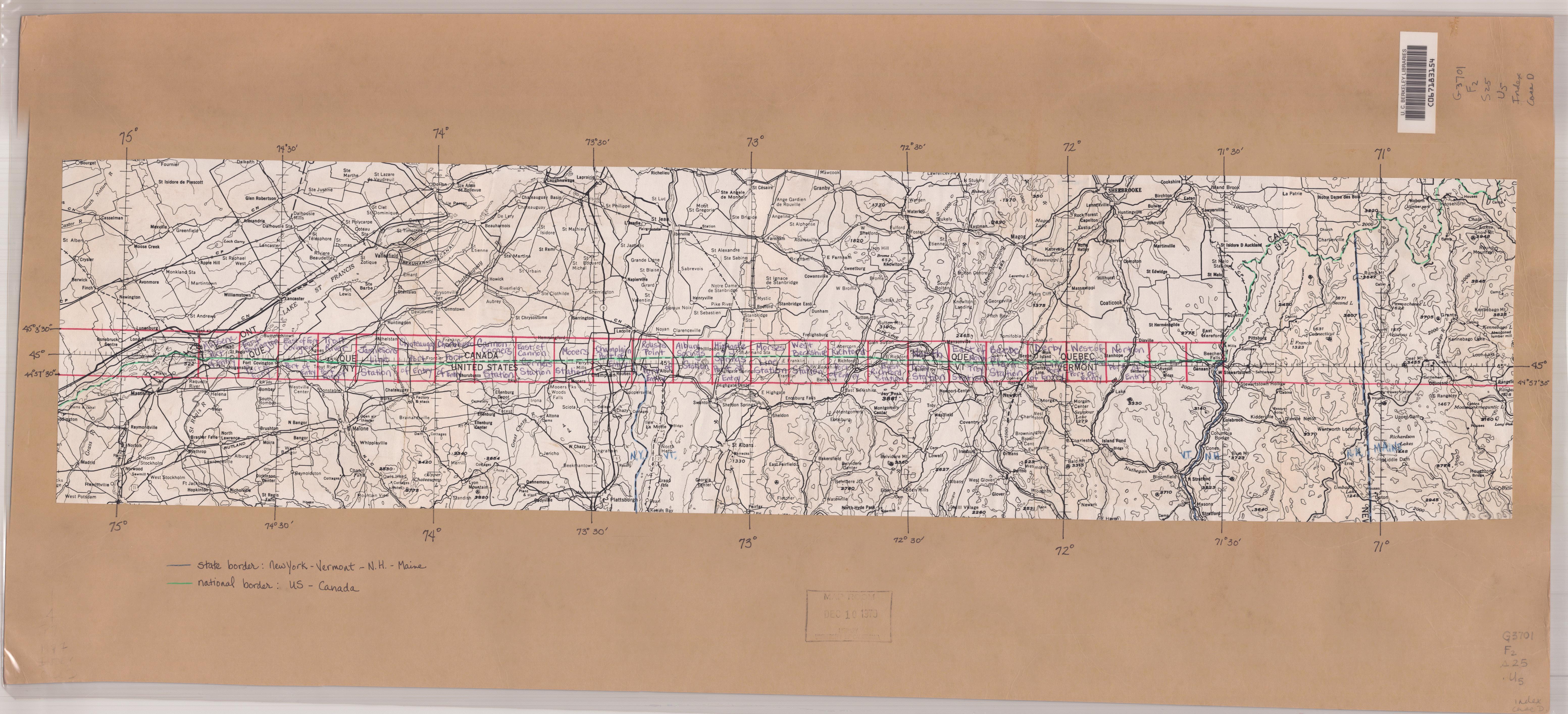
- Index map
Available Online
Items in the Library & Off-site
Filter by
1 Item
| Status | Format | Access | Call Number | Item Location |
|---|---|---|---|---|
Available - Can be used on site. Please visit New York Public Library - Schwarzman Building S4 to submit a request in person. | Map | Oversize | Map Div. 84-3035 | Schwarzman Building S4 - Map Division Room 117 |
Details
- Additional Authors
- Description
- 24 maps : color; 45 x 40 cm, on sheets 57 x 50 cm
- Alternative Title
- Color image map : [ports of entry, United States-Canadian border].
- Subject
- Genre/Form
- Remote-sensing maps.
- Maps.
- Note
- Shows border area between Quebec and New York, Vermont and New Hampshire.
- "Photoimagery rectified by optical scanning of simultaneously exposed B/W panchromatic and B/W infrared 1:70 000-scale aerial photographs taken October 28, 1975, by Department of Energy, Mines and Resources, Ottawa."
- Sheets include index to adjoining maps.
- Contents
- [Sheet 1] Alburg Springs Station -- [Sheet 2] Beebe Plain Station -- [Sheet 3] Cannon Corners Station -- [Sheet 4] Champlain Port of Entry -- [Sheet 5] Chateaugay Port of Entry -- [Sheet 6] Churubusco Station -- [Sheet 7] Derby Line Port of Entry -- [Sheet 8] East of Cannon Corners Station -- [Sheet 9] East of Fort Covington Port of Entry -- [Sheet 10] East of North Troy Station -- [Sheet 11] East Richford Station -- [Sheet 12] Fort Covington Port of Entry -- [Sheet 13] Highgate Springs Port of Entry -- [Sheet 14] Jamiesons Line Station -- [Sheet 15] Massena Port of Entry -- [Sheet 16] Mooers Station -- [Sheet 17] Morses Line Station -- [Sheet 18] North Troy Station -- [Sheet 19] Norton Port of Entry -- [Sheet 20] Richford Port of Entry -- [Sheet 21] Rouses Point Port of Entry -- [Sheet 22] Trout River Port of Entry -- [Sheet 23] West Berkshire Station -- [Sheet 24] West of Norton Port of Entry.
- Call Number
- Map Div. 84-3035
- OCLC
- 1007202351
- Author
- Geological Survey (U.S.)
- Title
- Color image map : [ports of entry, United States-Canadian border] / prepared and published by the U.S. Geological Survey in cooperation with the Department of the Treasury, U.S. Customs Service.
- Imprint
- Reston, Va. : The Survey, 1977-1978.
- Cartographic Data
- Scale 1:25 000 ; universal transverse Mercator projection (W 74°45ʹ00ʺ--W 71°45ʹ00ʺ/N 45°03ʹ30ʺ--N 44°57ʹ30ʺ).
- Type of Content
- cartographic image
- Type of Medium
- unmediated
- Type of Carrier
- sheet
- Connect to:
- Place of Publication
- United States.Canada.
- Added Author
- Canada. Department of Energy, Mines and Resources.Geological Survey (É.-U.)U.S. Customs Service.
- Added Title
- Color image map : [ports of entry, United States-Canadian border].
- Research Call Number
- Map Div. 84-3035